
There are times when you just want to escape from it all. Get away from the noise, distraction, and speed at which the world seems to be going, and return to nature. I did this recently and came back feeling refreshed, as if I’d reset my body and mind, and ready to take on the year ahead.
It was quite the adventure as I went solo, completely switching off from everyone and everything. What I saw took my breath away and allowed me to reconnect with my soul in a way I haven’t done in a long time.
Hiking might not be everyone’s cup of tea, but there is something very primal about it, especially when you have no one but yourself for company. It’s just magical, and many hiking trails in the US that deliver exactly that kind of magic.

9 Amazing Hiking Trails In the US Perfect For Solo Travelers
From coastal cliffs that plunge into turquoise waters to alpine ridges where you can see for miles, these hikes stick with you long after you’ve kicked off your muddy boots.
Maroon Bells Scenic Loop Trail, Colorado
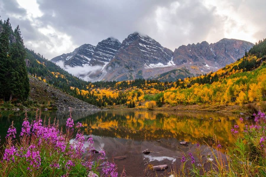
The Maroon Bells aren’t called the most photographed peaks in North America for nothing. When you see those twin summits reflected in Maroon Lake, you’ll understand why people can’t stop snapping pictures.
This 1.9-mile loop winds through aspen groves that turn golden in fall, crosses babbling streams, and in summer, wildflowers blanket the meadows in purple and yellow. It’s absolutely breathtaking and packs a lot of beauty into a short distance.
You get towering peaks, crystal-clear lake reflections, and that crisp mountain air that makes you want to fill your lungs and never leave. It’s perfect if you want spectacular scenery without the grueling elevation gain.
Get there early, ideally at sunrise, to beat the crowds and snag parking. There’s a shuttle service if the lot fills up, which it often does by mid-morning in peak season.
Key Information:
- When to go: June through October, with late September bringing peak fall colors
- Difficulty: Easy
- Distance: 1.9-mile loop
- Insider tip: The best reflections happen in early morning when the water is still – any wind after 9 AM ripples the lake and ruins that mirror effect everyone comes for
Kalalau Trail, Na Pali Coast, Kauai, Hawaii
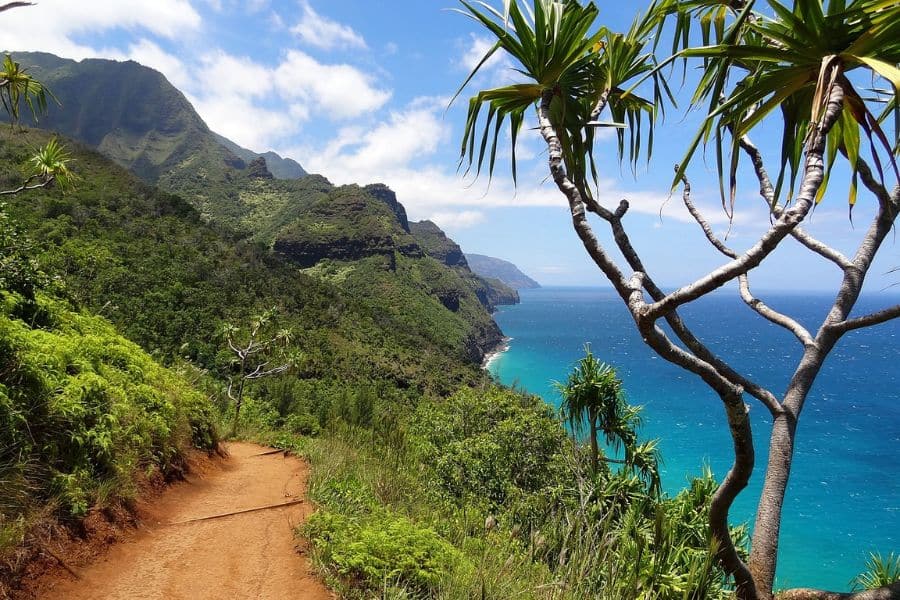
This 11-mile trail along Kauai’s Na Pali Coast is the stuff of hiking legends. Towering sea cliffs drop into turquoise water, waterfalls cascade down emerald valleys, and the whole experience feels like stepping into a lost world.
The full trail to Kalalau Beach is a serious undertaking that requires permits and typically takes two days each way. But you don’t need to commit to the whole journey. The first two miles to Hanakapiai Beach make for an incredible day hike, winding through tropical jungle before opening up to a secluded beach framed by those dramatic coastal cliffs.
If you do tackle the full trail, you’ll cross narrow sections carved into cliffsides, ford streams that can swell quickly after rain, and climb in and out of valleys that’ll test your legs. The reward? Camping on a remote beach with views that’ll make you question why you ever lived anywhere else.
Summer brings calmer seas and better weather, though the trail stays lush and muddy year-round. Winter can make stream crossings dangerous, and high surf can make beaches treacherous.
Key Information:
- When to go: May through September for the most stable conditions
- Difficulty: Challenging (moderate for the first 2 miles to Hanakapiai Beach)
- Distance: 22 miles round trip (4 miles round trip for day hikers)
- Insider tip: Pack reef-safe sunscreen – the sun reflects off those cliffs and water, and you’ll burn faster than you think
Bryce Canyon Rim Trail, Utah
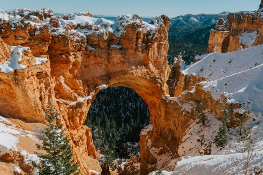
Walking along the rim of Bryce Canyon feels like someone turned the color saturation up to maximum. Those orange and red rock spires, called hoodoos, jut up from the canyon floor in formations that look like a fantasy landscape.
The full Rim Trail stretches 11 miles, but you can tackle it in sections. The most popular stretch runs from Sunrise Point to Sunset Point, just under two miles of relatively flat walking with constant views into the canyon. Every turn reveals a different perspective on those towering rock formations.
The elevation sits around 8,000 feet, so the air is thinner than you might expect. Take it slow if you’re coming from sea level. Winter hiking is possible, and snow on the hoodoos creates an entirely different kind of beauty, though some sections close when ice makes them dangerous.
Key Information:
- When to go: May through September for snow-free trails, though winter offers dramatic views
- Difficulty: Easy to moderate, depending on distance
- Distance: 11 miles total, or choose shorter sections starting at 1.8 miles
- Insider tip: Hike clockwise from Sunrise Point – you’ll have the sun at your back for better photos and the morning light hits the hoodoos perfectly from this direction
Angels Landing Trail, Zion National Park, Utah
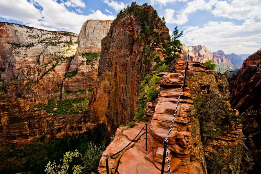
The final half mile of Angels Landing involves gripping chains bolted into rock while navigating a narrow spine with 1,000-foot drops on both sides. It’s not for everyone, but if you can handle the exposure, the views from the top are absolutely worth it.
The trail starts deceptively easy, following the Virgin River on paved switchbacks. Then you hit Walter’s Wiggles, 21 steep switchbacks carved into the cliff face in the 1920s that’ll have your calves burning. Scout Lookout comes next, where plenty of hikers turn around. The views here are already stunning, and there’s no shame in calling it quits.
But that last push to the summit is what people remember. The trail narrows to just a few feet in spots, and you’ll be using those chains to pull yourself up steep sections while trying not to look down at the dizzying drop. When you finally reach the top, Zion Canyon spreads out below you in every direction.
You need a permit now, issued through an online lottery system. They implemented this a few years back because the trail was getting dangerously crowded. Apply well in advance or try your luck with the day-before lottery.
Key Information:
- When to go: March through November, avoiding summer’s brutal midday heat
- Difficulty: Strenuous, with significant exposure
- Distance: 5 miles round trip
- Insider tip: Most people focus on the chains section, but the real bottleneck is Walter’s Wiggles on busy days – start early to avoid getting stuck in a slow-moving line on those switchbacks
Hoh Rain Forest Trail, Olympic National Park, Washington
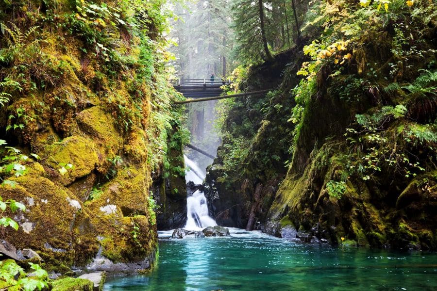
The Hoh Rain Forest is what happens when a temperate rainforest gets over 140 inches of rain a year. Everything is green. Moss drapes from massive Sitka spruce and western hemlock trees like something out of a storybook.
The trail offers options depending on how far you want to go. The Hall of Mosses loop is just 0.8 miles and gives you the full fairy tale experience in under an hour. Nurse logs support entire ecosystems, and the silence here is profound, broken only by the occasional bird call or stream trickling nearby.
If you want more, the trail continues 17.3 miles to Blue Glacier, though most people turn back well before that. Even a few miles in, you’ll see why this ecosystem is so rare. Ancient trees tower overhead, some over 300 feet tall, and the air smells rich and earthy.
Word of warning, this trail sees a lot of rain, as the forest needs it, and you’ll likely get wet even in summer. But hiking in the drizzle actually enhances the atmosphere, with mist clinging to the trees and everything looking even more vibrant.
Key Information:
- When to go: April through October, though prepare for rain any month
- Difficulty: Easy to moderate, depending on distance
- Distance: 0.8 miles (Hall of Mosses) to 17.3 miles (Blue Glacier trail)
- Insider tip: Come in late winter or early spring when the salmon are spawning – you might spot Roosevelt elk feeding along the river, and the forest is at its most lush after months of rain
Grinnell Glacier Trail, Glacier National Park, Montana
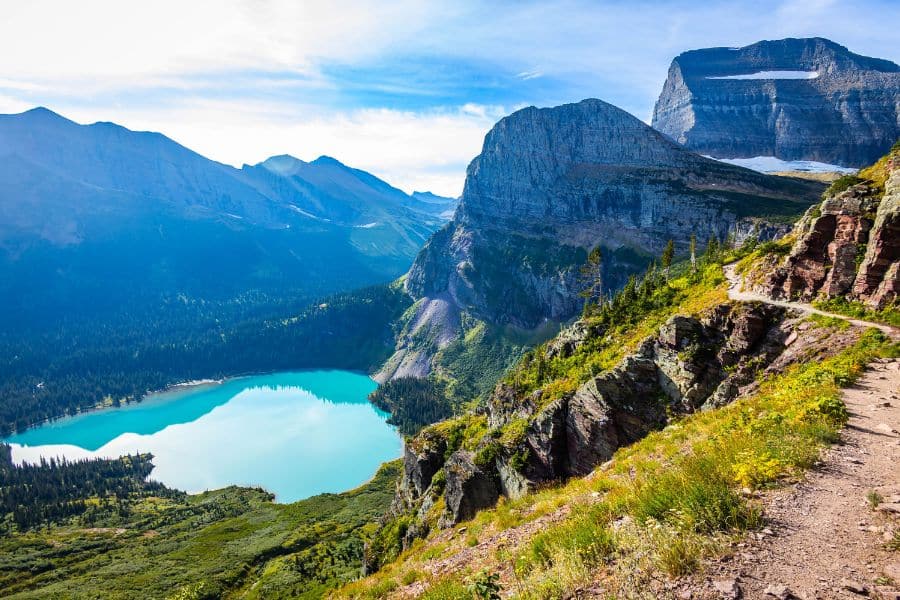
The turquoise water at Grinnell Glacier is so vivid it almost doesn’t look real. That electric blue-green color comes from glacial flour, fine sediment ground up by the glacier and suspended in the meltwater. Standing at the edge of the glacial lake with ice-capped peaks towering above is something you don’t forget in a hurry.
This 10.6-mile round-trip trail climbs steadily through alpine meadows exploding with wildflowers in July and August. You’ll pass several lakes along the way, each one offering a different perspective on the surrounding peaks. The final push to the glacier involves some steep sections and a bit of scrambling, but nothing technical.
Mountain goats often graze near the trail, completely unfazed by hikers and bears, so hiking in groups and making noise is smart. The glacier itself has shrunk dramatically over the past century. What used to be a massive ice field is now significantly smaller, a visible reminder of climate change.
Key Information:
- When to go: July through September, once the snow melts
- Difficulty: Moderate to challenging
- Distance: 10.6 miles round trip
- Insider tip: Start before 7 AM to catch the shuttle boat across Swiftcurrent Lake and Josephine Lake, cutting 3.4 miles off your hike and saving your energy for the glacier itself
Lost Coast Trail, California
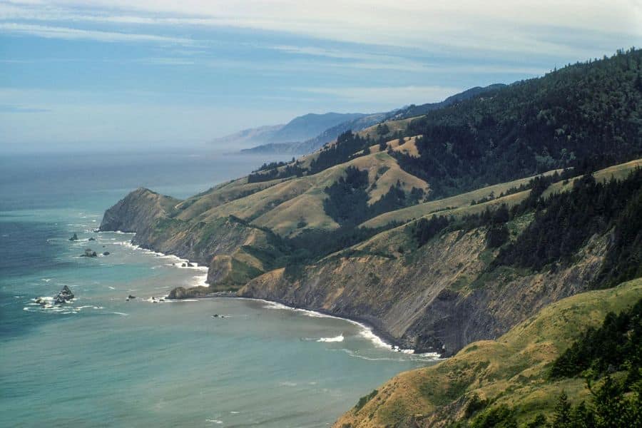
The Lost Coast earned its name because it was too rugged to build Highway 1 through here. What’s bad for road construction is perfect for hikers wanting true wilderness. This 25-mile stretch of California coastline remains gloriously undeveloped, with black sand beaches, towering cliffs, and the kind of solitude that’s increasingly rare.
Here’s the catch: you need to time sections of this hike around the tides. Some stretches are only passable at low tide, and getting caught by rising water against impassable cliffs is dangerous. Bring a tide chart and plan your camping spots accordingly.
Expect to see sea lions lounging on rocks, seabirds wheeling overhead, and maybe even migrating whales offshore if you hike in winter or spring. The beaches are littered with driftwood and tide pools, and sunset here is spectacular when fog isn’t rolling in.
The terrain alternates between walking on sand (harder than it sounds with a loaded pack) and scrambling over slippery rocks. Your feet will get wet, and unfortunately, there’s no avoiding it, so waterproof boots are essential.
Key Information:
- When to go: May through October to avoid winter storms
- Difficulty: Moderate to challenging, depending on tides and weather
- Distance: 25 miles point to point
- Insider tip: Download offline tide charts for the entire stretch before you go – cell service is nonexistent, and you’ll need to constantly check tide windows to safely navigate the boulder fields
Iceberg Lake Trail, Glacier National Park, Montana
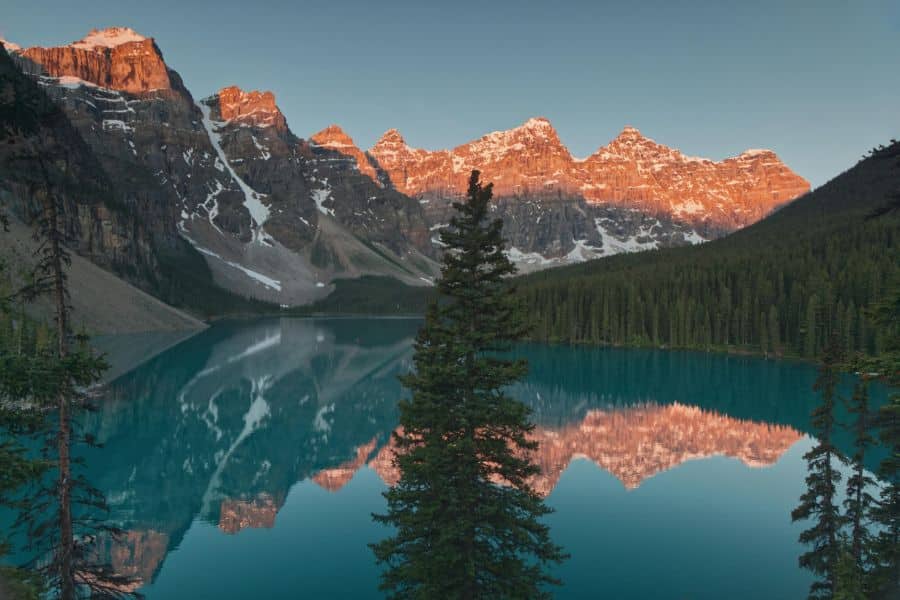
Even in July, you’ll find chunks of ice floating in this glacial lake. The lake sits in a massive cirque, surrounded by near-vertical cliffs that keep it shaded and cold enough for icebergs to persist through summer.
The 9.6-mile round-trip trail is straightforward and well-maintained. You’ll start in forests before climbing gradually into alpine meadows where wildflowers peak in mid-summer. The elevation gain is steady but manageable, making this accessible to most hikers with decent fitness.
Mountain goats are regulars here, often spotted on the cliffs above the lake or along the trail. They’re used to people but still wild, so keep your distance. The scenery shifts constantly as you hike deeper into the mountains, with waterfalls appearing around bends and new peaks coming into view.
The final approach to the lake is dramatic. The trail opens up to reveal the cirque in all its glory, with those towering walls and the impossibly blue-green water dotted with white ice. Most people spend at least an hour here, eating lunch on the rocky shore and soaking in the view.
Key Information:
- When to go: July through September, when the trail is snow-free
- Difficulty: Moderate
- Distance: 9.6 miles round trip
- Insider tip: The icebergs are largest and most plentiful in early Jul,y right after snowmelt – by late August, they’ve mostly melted, and you might only see a few small chunks
Franconia Ridge Loop, New Hampshire
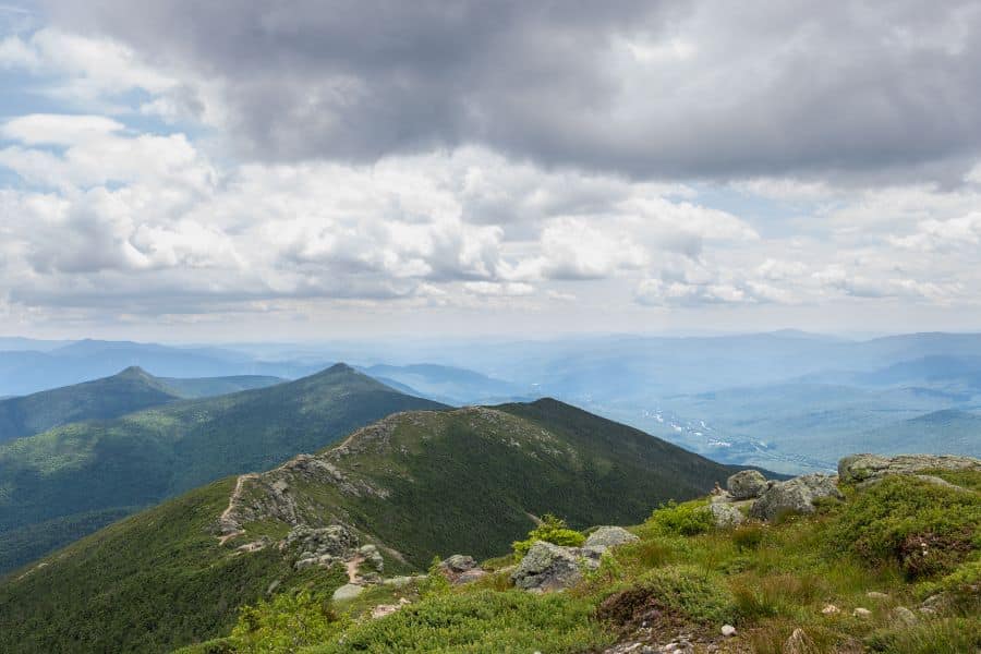
This 8.9-mile loop packs serious elevation gain and some of the best alpine ridge walking on the East Coast. Once you break above treeline, you’re exposed to whatever weather the mountains throw at you, and conditions can change fast.
The payoff is the ridge walk between Mount Lafayette and Mount Lincoln. For nearly two miles, you’re walking along an open ridge with 360-degree views. On a clear day, you can see into Vermont, Maine, and Canada. The rocks underfoot are ancient, and the alpine plants clinging to life up here are tough as nails.
Most hikers go counterclockwise, starting up the Falling Waters Trail and descending via the Greenleaf Trail. The Falling Waters section is steep and rocky, gaining about 3,000 feet in less than three miles. Your quads will feel it. But once you’re on that ridge, the struggle fades into background noise.
Fall brings leaf peepers and stunning foliage, but also unpredictable weather. I’ve hiked this in September sunshine and been hit by sleet an hour later. Layer up, bring wind protection, and don’t push it if clouds roll in. People die on these mountains when they underestimate them.
Key Information:
- When to go: June through October, with September offering spectacular fall colors
- Difficulty: Strenuous
- Distance: 8.9-mile loop
- Insider tip: Check the Mount Washington Observatory higher summit forecast before you go – if winds are forecast above 40 mph on Washington, the ridge will be brutal and potentially dangerous
Disclaimer: This article is for general information only and is not professional advice. It may contain affiliate links. Please see our full Editorial Policy for details.

Kylie Lang is a nationally syndicated travel journalist with bylines on the Associated Press Wire & more, a lifestyle writer, and the founder and editor of Your Lifestyle Library (yourlifestylelibrary.com). She holds a BA (Honours) in History from the University of Kent and is a member of the British Guild of Travel Writers.